
The Resilient Mystic Collaborative (RMC) has released the results of a two-year groundbreaking research project involving six cities and 13 infrastructure managers to identify and manage risks to Greater Boston’s critical infrastructure from a potential major coastal storm. The Lower Mystic Regional Climate Assessment involved more than 400 residents and workers most at risk of harm from infrastructure failure and identified how a hypothetical coastal storm, termed “Big Papi,” would impact Lower Mystic River watershed communities.
In 2020 six lower Mystic River watershed communities – Charlestown, East Boston, Chelsea, Everett, Revere, Somerville and Winthrop – secured a $390,000 regional Municipal Vulnerability Preparedness grant to understand the critical investments needed to fortify regional infrastructure from a major coastal hurricane or nor’easter. This grant and a second grant from the Barr Foundation allowed Arup, All Aces, Inc., the Mystic River Watershed Association (MyRWA), CH Consulting and six community-based organizations to produce the assessment. The six community-based organizations – La Comunidad in Everett, GreenRoots in Chelsea, The Harborkeepers in East Boston, Community Action Agency of Somerville, Somerville Community Development Corporation and TCGT Entertainment in Boston – were intentionally place-based within the six municipalities to ensure trusted community engagement.
“With climate change causing more frequent extreme weather, we have to plan for how to best protect our communities, especially our residents who are most vulnerable to the effects of extreme weather,” said Somerville Mayor Katjana Ballantyne. “Information from this climate assessment has already helped us update our own Hazard Mitigation Plan and will be valuable in our continued work to center equity in our climate change mitigation planning.”
By completing a dual climate assessment – one focused on infrastructure and the other on social vulnerability – the municipalities gained valuable insight from key infrastructure managers and Greater Boston’s vulnerable residents and workers, including:
- The most substantial infrastructure damage (i.e., cost and time to repair) would be to the Amelia Earhart Dam, Harbor Tunnels, Blue and Orange MBTA Subway Lines and several community health centers.
- Underlying social risk factors would include speaking limited English and being a person of color, Latinx or low-income; these residents tended to be concentrated in East Boston, Chelsea, Revere and Everett, the same locations where most of the critical infrastructure is located.
- Vulnerable communities had fragile mutual aid networks and an overly optimistic expectation of government readiness and response; residents were unclear where to go to get the information needed to stay safe and worried about their cell networks going down, which are their primary source of internet access.
- The regional infrastructure facilities vulnerable residents and workers most relied on were public transit and safe walking routes, cell phone/electricity to access the internet, and community health centers.
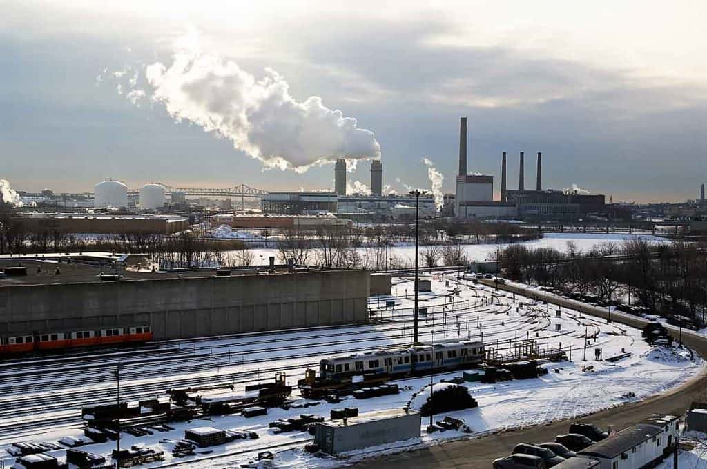
When Superstorm Sandy hit New York and New Jersey, it caused lasting physical damage to the region’s infrastructure, and economic and personal damage to possibly millions of residents and workers. The Boston metropolitan region was lucky to escape such detrimental impacts from Sandy, though the storm still left thousands without power. The lower Mystic River watershed is home to the most concentrated assembly of critical infrastructure north of New York. The Department of Homeland Security (DHS) recognizes 16 critical infrastructures as lifeline sectors “whose assets, systems, and networks, whether physical or virtual, are considered so vital to the United States that their incapacitation or destruction would have a debilitating effect on security, national economic security, national public health or safety, or any combination thereof.”
Of these 16 lifeline sectors, the lower Mystic River watershed is host to at least five:
- Transportation: Logan International Airport, three MBTA rail lines, the Ted Williams and Callahan tunnels.
- Food distribution: the New England Produce Center.
- Energy: more than 100 fuel storage tanks, the Mystic Generating Station.
- Wastewater management: Deer Island Wastewater Treatment Plant.
- Dam: Amelia Earhart Dam.
The lower Mystic River watershed is also one of the Northeast’s densest residential areas, with tremendous socioeconomic diversity, wealth disparities and environmental justice (EJ) concerns. For example, Everett and Chelsea are two of only six areas in the state where 100 percent of residents live in an EJ block group, as defined by the state.
“The pandemic made clear to the public how low-income residents and workers of color are often the first and worst to be affected by major public health emergencies,” said La Comunidad Executive Director Antonio Amaya. “Unfortunately they are also among the most at risk from extreme weather such as big coastal storms. I’m glad to see this assessment focus on their needs first and foremost.”
One of the Resilient Mystic Collaborative’s highest priorities is to storm-harden critical regional infrastructure so that extreme weather events don’t lead to cascading health and economic losses for the residents and workers who can least afford them. By centering social vulnerability and listening to the lived experience of residents and workers expected to be most negatively affected by damage to critical regional infrastructure, this assessment shifts the central question from “How much real estate value is at risk?” to “Who among us stands to lose the most?”
“The Big Papi exercise was extremely helpful to our thinking about what we need to do to prepare for Boston’s own Superstorm Sandy or Hurricane Maria. We have looked at our own vulnerabilities, but had to make assumptions about those of other systems,” said the Massachusetts Water Resources Authority’s Director of Planning and Sustainability, Stephen Estes-Smargiassi. “Going through a simulated big storm with the other infrastructure managers helped us all identify cascading effects and how the loss of electricity, fuel, transportation, or communications would affect our staff, our customers, and our ability to stay on line.”
Currently, the Resilient Mystic Collaborative municipalities are developing projects to address key findings and recommendations, ensuring a focus on the primary needs of vulnerable people in the lower Mystic River watershed.
“The Lower Mystic Regional Climate Assessment reveals opportunities for Massachusetts’ environmental justice communities most impacted by climate change to be engaged in informing actions to reduce the impact of climate emergencies,” said All Aces, Inc. Founder/CEO Dr. S. Atyia Martin. “All Aces was proud to partner with the RMC on this critical project. We urge policymakers and community leaders to carefully consider these results and take the necessary steps to ensure that efforts to strengthen resilience center those disproportionately bearing the burden of threats and hazards we face.”