
“The threat is real and is happening now”
(Editor’s Note: The following document was prepared by Robert Hunt, who worked for 33 years as a project manager for the U.S. Army Corps of Engineers and was heavily involved with the Regional Saugus River Floodgate Project, which focuses on the communities of Revere, Lynn, Saugus, Malden and Everett. Precinct 10 Town Meeting Member Peter Manoogian included this document with a letter addressed to the Saugus Board of Selectmen, which he requested to be discussed at Tuesday night’s Board meeting along with the Jan. 13 flooding in Saugus. Manoogian is urging selectmen to endorse the Saugus River Floodgate Project and to communicate such action to state and federal political leaders.)
January 13, 2024
On February 6 and 7, 1978, a major northeaster hit the New England coast, a 100-year storm. The Blizzard of ’78, as it came to be called, caused widespread damage to coastal communities and residents. The Saugus River Watershed was particularly hard hit, with extensive damage in Revere, Lynn, Saugus, Malden, and Everett, MA. Flooding over much of the lower watershed was 4 to 7 ft deep and up to 3-feet higher in elevation than tide levels at the Boston gauge because of normal high tide, storm surge, and storm-driven waves. These flood waters damaged over 3,100 buildings, affected 10,000 residents and 20,000 employees, and cut off transportation for 400,000 commuters. Homes were without heat, electricity or means of evacuation. Two homes burned because roads were impassable.
Damages were estimated at $72 million in 1978 dollars, equivalent to $332 million in 2023 dollars.
Since then, things have only gotten worse with significant flooding every few years, twice in 2018, a record high in Boston, and three in 2024, 4th & 6th highest of record! Also alarming, by 2030/34 with a 1+ foot rise in sea level: most properties around the estuary will see flooding twice a month during high spring tides; a 10-year storm becomes an annual event; and the Blizzard of ’78 storm tide becomes a 10-year event, and by 2050, a 2-year storm.
The Standard Project Northeaster (or SPN), the worst storm likely to occur, would add at least two feet to the ’78 tide level, and accelerated sea level rise (SLR) by 2050 would add another 2.5 feet according to the Massachusetts Coastal Zone Management (CZM) Office.
This would cause a potential depth of 10 feet over many of the low-lying areas of the five communities lasting several days to weeks. This would damage over 6,000 structures, displacing about 30,000 residents, as many employees, and stranding half a million commuters. By the turn of the century, 2100, CZM adopted an expected sea level rise of 7.8 feet above 2008 levels!
Current damages from the SPN would exceed $1 billion and by 2050 $2 billion. The threat is real and is happening now, flooding low-lying properties several times a month.
Driven by the affected municipalities, the Commonwealth and the Federal government began seeking methods to reduce these potential damages. The Regional Saugus River Floodgate Project was planned and designed over eight (8) years (1985-1993) at a cost of $8.6 million ($20 million at todays’ dollars) by the Army Corps of Engineers with the help of Citizen Steering Committees from Lynn, Malden, Revere, and Saugus and a Technical Group of Federal and state agencies and private environmental interests to reduce coastal flood damages from storms such as the Blizzard of ’78 and larger storms, while protecting the estuary.
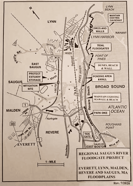
Three major alternatives were considered: Option #1, Local Protection Plans which relied on 10 miles of walls up to 8 feet high above yards and roads surrounding flood-prone areas. This plan, while economically feasible, blocked views for many residences; Option #2, Nonstructural Measures examined raising or floodproofing individual structures. Only 240 buildings (7%) were found suitable for this approach and no protection could be provided for transportation and other infrastructure. These plans were unacceptable to all participating communities; and, Option #3, the Regional Project would provide protection against the SPN for all structures and critical infrastructure in the Region, but need modifications if sea level rise accelerated. It includes new walls and dikes with walkways along 1.7 miles of Lynn Harbor; 0.6-mile sand dune and beach at Point of Pines with a new river wall; and 0.6-mile raised parkland behind Revere Beach and a ponding area; and, a major floodgate structure at the mouth of the Saugus River with nine (9) gated openings (50 & 100 feet wide) to maintain natural flushing in the estuary and safe navigation. The total cost was $250 million at 2023 price levels (’23pl), including purchasing and protecting the 1,650-acre estuary for flood water storage. The Regional Project was economically justified with 64% Federal cost sharing as authorized by Congress in 1992, and was widely supported, but it was placed on hold in 1993.
By 2023 accelerated sea level rise was adopted at “high” but different rates by both the Commonwealth and the Federal government which would require modifications to the Regional Project. The Corps’ retired Project Manager (PM), with the help of both his Environmental Manager and the MA Assistant Secretary of Environmental Affairs during the initial investigation, and folks in the region, all helped to remind the communities in 2020 that the project would still protect them from accelerated sea level rise. The five communities then sponsored a letter of support to have the Corps review and update the project with a required Corps’ study, the Boston North Shore Feasibility Study, up to a 3-year effort depending on the scope of work, which was authorized by President Biden in December 2022, but is yet to be funded.
The Regional Project, Option #3, was reviewed to inform the communities of some likely changes and impacts from sea level rise, previously described in the EIS/EIR, focusing on the 5 feet of sea level rise above 2000 levels adopted by the Corps for 2100, provide the SPN level of protection, and prevent pollutants from entering the estuary. See the Option #3 map for the modified Regional Project. Over the next ten years with over half of properties along the rivers prone to flooding several times a month from rising high tides, residents would likely protect their properties with low level walls or berms, just as Revere is currently developing along Riverside. By 2034 when a Regional project could be built, the Floodgates would close several times a year to prevent damage from intense storms, catastrophic flooding, and overtopping of walls, but increase operations with rising sea levels. The Feasibility study would evaluate when walls would need to be raised a few feet, to raise the start of damages, and to reduce the number of closures and potential impacts on navigation and the estuary.
Sand dune/beach systems using I-95 sand proved the most effective solution to prevent overtopping based on results from post storm surveys, and physical and numerical modeling.
Revere Beach, previously restored with I-95 sand, and Point of Pines would benefit from 3.4 miles of dune/beach systems to prevent overtopping the oceanfront and protect the region from higher tides and more intense storms. Protecting the Nahant Causeway, assumed using a dune/beach system, is needed since it reduces wave action in Lynn Harbor, at Point of Pines, and at the entrance to the Saugus River. Plans exclude raising bridges which have been raised or planned to be raised.
The modified Regional plan to include the Revere and Nahant dune/beach systems would cost about $300 million (’23 pl) to protect the region against the SPN through 2100 while sea levels rise 5-feet. If low-level walls (3 to 6 feet) are required, it would increase the plan’s cost to a maximum of about $185 million, for a total project cost of $485 million.
The Study would also consider other options, including a Wall Only Option #1 Plan (without a floodgate) for 2100, a 5-foot rise in sea level and SPN protection, which would require walls up to 12 feet high above the back yards of residents and along roadways which would significantly obstruct views around the estuary’s 25-mile shore at a cost of about $580 million (’23 pl).
A Non-structural Option #2 Plan would require raising homes and other buildings up to 12 feet high at a cost exceeding $540 million; however, streets, roads and yards would be frequently inundated. An option for total retreat and removal of all buildings from the floodplain would likely double the initial estimate of $7.3 billion (’23 pl) with the larger sea level rise floodplain.
The restoration of Rumney Marsh, a Massachusetts’ “Area of Critical Environmental Concern”, is an added environmental benefit of the Regional Plan prepared with the help of the US Environmental Protection Agency team member. It would include removal of the abandoned I-95 embankment, create over 40 acres of wetland, and reconnect and enhance the upper estuary’s 500-acre salt marsh. Restoration would return natural flushing and tide levels to the marsh; enhance the habitat for wildlife, birds, and 38 species of finfish; stop deterioration of wetlands; and nearly eliminate phragmites reeds, marsh mosquitos, and frequent fires. All available I-95 sand would be used for the Revere and Nahant dune/beach systems.
The Regional project, extensively reviewed under the National Environmental Policy Act and the Massachusetts Environmental Policy Act, achieved approval and favorable comments in 1990. The MA Secretary of Environmental Affairs then assigned the Metropolitan District Commission as the state sponsor. Even so, a new Secretary of Environmental Affairs, opposed to construction along the coast, called a halt to the project in 1993 to allow further examination of non-structural measures by the Commonwealth. These analyses are only now being accomplished.
With sea level rise accelerating and greater risks from climate-change enhanced storms becoming more intense in the mid-2030s and 40s, it is critical that the updated Feasibility Study be initiated as soon as possible either by the Federal Government or the Commonwealth, and if a project is approved by both, it should proceed immediately into final design. The communities are seeking support and up to $3 million (50/50 Federal cost share) for this Boston North Shore Feasibility Study.
Information on the problems, solutions, environment, photos, Design and Feasibility Reports, EIS/EIR, Environmental Secretary’s Certificate, and Sea Level Rise Plans are available on the website: www.saugusriverfloodgates.com.
For general questions call Elle Baker, Revere Project Planner, at eb****@****re.org or 781-286-8188. For questions or a zoom presentation on the project, contact Bob Hunt, former Corps of Engineers Project Manager, at bo**********@*****il.com or 617-633-3974.